Wednesday, July 15, 2015

Travelin' the Trace to Tishomingo


The Natchez Trace Parkway is a designated National Park and rightfully so.   Spanning 444 miles through 3 states and encompassing 10,000 years of history, the Natchez Trace Parkway is a treasure trove for those who love nature, history and have a hunger for exploration!  Along our journey to the beautiful Tishomingo State Park (located in the northeastern quadrant of Mississippi), our Frugal Family Travelers stopped at several locations on the northern end of the Mississippi section of the Natchez Trace Parkway. The pictures and discriptions below will provide you with options for places to visit in this area, should you choose to add any of these areas to your bucket list.

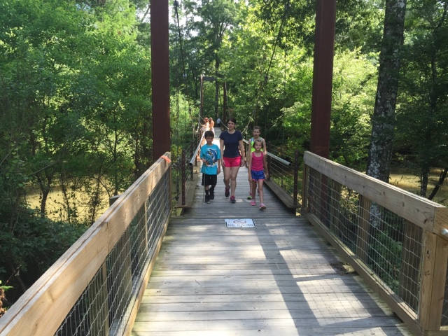
As mentioned earlier, Tishomingo State Park was the main travel target on our journey and it did not disappoint.    Being that it was only 5 hours from New Orleans, this park was the perfect "get-away" for our Frugal Family Travelers.   With canoeing, hiking and history wrapped up in a mountain setting, Tishomingo gave us the feeling we were nestled in the mountains when we were actually in the foothills of the Great Smokies.   We enjoyed our stay in one of the rustic cabins built by the Civilian Conservation Corp (CCC) and spent our evening there grilling and making smores! By day we explored a trail leading over a swinging bridge (also built by the CCC) and hiked yet another to a pioneer cabin.   The highlight of our experience here was a  6.25 mile canoeing trip on Bear Creek.  With cypress tree littering nearly every inch of its banks, Bear Creek literally looks like something out of a movie. The patches of white water kept the trip exciting but were not overwhelming for our younger paddlers!  We loved our entire visit here and highly reccommend this park!

Outside of rustic cabin.  Approximate price is $60 per night.  

Swinging Bridge

A view of Bear Creek!

Indian Trail Tree encountered while hiking.

Trail to pioneer cabin.

Scenes while canoeing on Bear Creek. There is a $30 canoe rental fee.  Make a reservation with the park office (662-438-6914).   Younger paddlers 7 and under may ride in the center of the canoe.   Lifejackets and paddles are provided along with transportation to the beginning of the float trip.


The following are scenes from the Northern Mississippi portion of the Natchez Trace Parkway and the towns surrounding the parkway.


Elvis' birthplace in Tupelo, MS:  We stopped a viewed everything from the outside however there is a museum and tour of the home offered for a fee. 


Cave Spring is a stop right off the Natchez Trace Parkway very close to Tishomingo State Park.

Indian Mounds off Natchez Trace Parkway

We viewed a great movie regarding the history of the trace and also saw an exhibit at the Parkway Visitor's Center, milepost 266, Tupelo, MS

Disclaimer:
All content provided on Frugal Family Travelers blog is for informational purposes only. The owners of this blog make no representations as to the accuracy or completeness of any information on this site or found by following any link on this site.  The owners of Frugal Family Travelers blog do not share personal information with third-parties and are not responsible for the republishing of the content found on this blog on other Web sites or media without permission.  As with all travel, operating days, times, costs, etc., should be verified prior to departure.

Monday, July 13, 2015

White Water Tubing!!


Our Frugal Family Travelers love the water!  In fact, any chance we get to be in the water, on one of our adventures, we take advantage of the opportunity!  On a recent visit to Tennesse we discovered River Rat Tubing, which is located in Townsend.  Townsend is adjacent to the Gatlinburg and Pigeon Forge areas and is just a short driving distance.   River Rat is a family owned and operated business which offers the best tubing experience in the area, including mild or wild tubing trips on the Little River!   Being that our Frugal Family Travelers are younger, we chose the mild trip!   Our float trip did not disappoint and was very adventurous!   The mild trip begins right at the main outpost in Townsend with transportation provided back at the end of the trip!  Check it out if you are in the area.   You won't be sorry ou did!!   Enough said......the pictures below are worth a thousand words!!

Cost: 

$15.00 per adult, $12.00 for children 6-12. Children five and under are FREE!  Rates include free transportation, life jackets and ALL DAY tubing fun on either or BOTH the upper and lower Little River.

Tips:  

Pack sunscreen, a small net to carry a bottle or two of water or sunscreen on the water

Directions: (click below to open Google Maps)

Smoky Mountain River Rat


Disclaimer:
All content provided on Frugal Family Travelers blog is for informational purposes only. The owners of this blog make no representations as to the accuracy or completeness of any information on this site or found by following any link on this site.  The owners of Frugal Family Travelers blog do not share personal information with third-parties and are not responsible for the republishing of the content found on this blog on other Web sites or media without permission.  As with all travel, operating days, times, costs, etc., should be verified prior to departure.

A Great Place for Summer Fun on the Northshore!


Tickfaw State Park is located right outside Hammond, LA in Springfield.  Wooded and lush, it is the perfect place to spend a day hiking, canoeing or cooling off at the splash pad. For those looking for a vacation or weekend getaway, the cabins and camping sites will provide the atmosphere for which you are looking.   For those who enjoy hiking, the river trail is beautiful, as it actually parallels the river for the greater part of the hike, which provides an opportunity to observe all sorts of wildlife. There is also an amazing bridge at the end of the trail which joins the boardwalk trail, creating a loop back to the parking area.   "Loop" simply means that the trail will take the hiker back to the original departure point. Those traveling with kids will appreciate loop trails because they take the guesswork out of the hike and eliminate backtracking.  If you enjoy fishing, take a break at the bridge, and cast your fishing line to get your "catch of the day".   However, make sure to purchase a fishing licence from the Department of Wildlife and Fisheries  before casting that line into the water as a licence is required to do so.     Note: Access to the river trail is gained from the parking area down the road from the day use area which contains the splash pad.  Enjoy and picnic at the Bottomland/Hardwood Pavillion after your hike or at any of the designated picnic areas in the park.  See the map below for the locations of all of the offernings in the park!   Place a call to the park office before you depart if you plan to canoe.  In times when water levels are too high or low canoeing is not allowed.

If you are a frequent follower of our blog you know how Frugal Family Travelers feel about the State Park System and capitalizing on an annual membership!  At only $80, it provides each person traveling in the same vehicle with a pass holder, admission and access to all Louisiana state parks and historic sites.  If you frequent the parks, it is a great savings.   Explore the Louisiana State Parks website for a full list of parks and historic sites offered and begin planning your travel with a stop at Tickfaw.   Explore our blog to discover reviews of other state parks and take advantage of our page listing Frugal Family Adventures listed by state!


Cost:

$2 per person;  Seniors (62 and older) and children (3 and under) are free!

Directions (click below to access Google Map):

27225 Patterson Road Springfield, LA 70462-8906

Tips:

Bring sunscreen, towels for the splash pad, water, backpacks for hiking,  BUG SPRAY and don't forget your fishing licence!  


Cooling off at the splash pad after the hike!! 


Disclaimer:
All content provided on Frugal Family Travelers blog is for informational purposes only. The owners of this blog make no representations as to the accuracy or completeness of any information on this site or found by following any link on this site.  The owners of Frugal Family Travelers blog do not share personal information with third-parties and are not responsible for the republishing of the content found on this blog on other Web sites or media without permission.  As with all travel, operating days, times, costs, etc., should be verified prior to departure.

Friday, July 10, 2015

National Forests are National Treasures--Bankhead National Forest in Northwest Alabama


Lots of folks travel to the Great Smoky Mountains National Park each year.   The Smokies are certainly beautiful but with a reported 10 million visitors in 2014 alone, the park can be very crowded, especially during the summer months.   Why not "shake it up" a bit and try visiting a National Forest?  National forests, in the humble opinion of Frugal Family Travelers, are a best kept secret with adventures to be had by visitors, young and old alike.  If you enjoy hiking, picnicking and a peaceful respite by a waterfall, consider a trip to Northwestern Alabama to visit the Bankhead National Forest. It is certainly not as crowded as the Smokies and will not disappoint those seeking outdoor beauty.  Frugal Family Travelers recently paid a visit here and discovered some picturesque places that make this location worth a visit!    It is important to note, that this national forest is vast and therefore very easy to get lost without proper directions.   We strongly suggest making a stop to the ranger station for maps and detailed directions.  We visited and found the staff very friendly and helpful!  Frugal Family Travelers does provide directions to the sites we visited in this post because some are "off the beaten path" and not listed in literature by Bankhead National Forest.   These particular trails are very primitive and not always well maintained. Also, be aware that these hikes are strenuous and can lead to areas with steep "drop offs".  Furthermore, it is not uncommon to discover yourself on an unpaved road when following driving directions to a waterfall or trailhead!  The above information is not meant to scare any of our readers or discourage your visit but to make you aware of  what is to be encountered on your journey, should you choose to visit this location.  As stated above, this is an amazing location and our Frugal Family Travelers definitely viewed this as a highlight of our trip.  See the pictures below which outline each of the places we visited in the forest and also directions to each location. 

Cost:  

We encountered a fee area in the Sipsey Wilderness Picnic Area and parking lot with an honor box requiring $3.  Bring some dollars with you, in the event you encounter a fee area like this.  However, we did not come across any other fee areas.

For information about camping click here!

Directions:

The following pictures show the trail leading to Turkey Foot Falls.  It is one that is "off the beaten path" in that it is not listed in the national park literature: 

TURKEY FOOT FALLS AND CANYON--- There are 2 very nice sized waterfalls, 3 with sufficient rainfall, a rock shelter, and remains of a 1936 ford sedan located here. To see this place, park in the upper parking lot at the Sipsey River Picnic area, walk across the wooden bridge between the 2 parking lots, just as you cross, turn right and pick up the trail, follow it up into the canyon. You will come to a small falls on the creek, its about a 3 foot drop, continue on and you will come to the fram of a 1936 ford sedan. As you continue on up the canyon, you will pass a rock shelter and some large impressive bluffs. Shortly you will come to lower turkey foot falls to your right, cross the creek just past where they meet to get over to the falls. Come back across the creek and head up the hill to your right and walk next to some more bluffs. In a few minutes you will have to drop down a steep and slick hill to the creek to cross over to get up to turkey foot falls, or mize falls as some call it. When you leave you can walk out the way you came in. 
(Directions above credited to http://sipseywildernessphotos.webs.com/)


The following pictures show the trails leading to the upper and lower Caney Creek Falls:
CANEY CREEK FALLS AND CANYON--- The directions to the upper falls can also be obtained by the National Park Service.   However, the directions to the lower falls can be found below and are not provided by the National Park Service.  To first reach the falls, go west on hwy 2 from hwy 33 about 4 miles, there is a small parking area on your right, with a gate blocking a road, park here and follow the road for about 30 minutes (about a mile) to the falls. It is in a residential area and not easy to find.   Talk to a ranger to be clear.   Follow this trail to the upper falls.   Once you are at the upper falls, cross the creek below the pool, be very careful crossing here, once across, you can walk around to your left under an overhang, which is really nice, you can even have a picnic on the sandbar. Head downstream to the lower falls, follow the creek, there is a trail to follow. You will have to cross the creek 3 times on your way down, but its worth it. The lower falls are much wider, but without enough rain, they wont be very wide. The lower falls also drops into a pool. To get down to the falls, continue on downstream on the right side, you will be walking on a side of a hill, the trail then turns left and goes downhill, and yes, it is very slick here, make your way down around a nice rock shelterand back upstream to the falls, once there, there is a smaller falls to your left. Above this smaller falls a short piece is another waterfall, its not very big, but it is nice. The walk downstreamfrom the upper falls will take at least 45 minutes.
(Directions above credited to http://sipseywildernessphotos.webs.com/)

The following picture represent Kinlock Falls:

Take Highway 33 South; turn right on Highway 278, then take a right on Highway 195 North.  Go approx. 11 miles, turn right on CR 23 in Rabbittown (this road will become Forest Serice Road 210).  Stay on CR 23 and when it turns to gravel approx.  3/4 mile, immediately before the bridge there will be a pull off area.  Falls are on the right side of the road.  Note: this is a narrow road and the pull off is quite small so be prepared!  You will possibly find people sliding down the falls and or swimming below.   Talk to a ranger about the water levels and dangers involved BEFORE doing so.  There is no lifeguard on duty and this area could be very dangerous for swimming with varying water level!  Kinlock Falls can be heard as soon as you exit your vehicle and is just a short walk from the main road.


Tips:
Hike times vary for those of varying age and skill - factor in extra time.   Never enter a long trail at dusk! Pack a first aid kit, water, bug spray and snacks! Most of the time there is NO cell service in the National Forest so let someone know when you enter and depart a trail. 

Disclaimer:
All content provided on Frugal Family Travelers blog is for informational purposes only. The owners of this blog make no representations as to the accuracy or completeness of any information on this site or found by following any link on this site.  The owners of Frugal Family Travelers blog do not share personal information with third-parties and are not responsible for the republishing of the content found on this blog on other Web sites or media without permission.  As with all travel, operating days, times, costs, etc., should be verified prior to departure.